

Table of Contents
🌍
From Patagonia to the World: An Illustrated Timeline, 1772–1870
Age of Exploration (1772–1789) | Siege of Quebec (1775–1776) | Declaration of Independence (1776) | Battle of Frog’s Neck (1776) | Princeton & New Jersey Campaign (1776–1777) | Naval History (1776–1812) | European Architecture (1789) | Anti-Slavery Movement (1840) — with Full-Size Images, Copyright Licenses, GPS Locations, and Primary References
📑 Table of Contents
- 1772–1789: Exploration & Voyages
- 1775–1776: The Siege of Quebec
- 1776: Declaration of Independence
- October 1776: Battle of Frog’s Neck
- December 1776–January 1777: Princeton & the New Jersey Campaign
- 1776–1812: Naval History — Commodore Joshua Barney
- 1789: Architecture & Culture — The Reformed Church, Copenhagen
- 1840: The Anti-Slavery Movement
- Primary Scientific References
🧭 1772–1789: Exploration & Voyages to the Southern Hemisphere
The late 18th century witnessed an unprecedented wave of scientific exploration that carried European vessels to the remotest corners of the globe. The most consequential of these was Captain James Cook’s Second Voyage (1772–1775), undertaken aboard HMS Resolution and HMS Adventure. Departing Plymouth, England on July 13, 1772, Cook was tasked by the British Admiralty with resolving the question of Terra Australis Incognita — the hypothetical great southern continent that geographers had theorized about since antiquity. Cook sailed southward via the Cape of Good Hope, becoming the first navigator to cross the Antarctic Circle on January 17, 1773, at 66°33′S. He penetrated deep into the Southern Ocean pack ice, reaching 71°10′S — a record that would stand for nearly 50 years — before being turned back by impenetrable ice. Though Cook never sighted the Antarctic continent itself, he conclusively demonstrated that any southern landmass, if it existed, lay within the polar ice zone and was not the temperate, fertile continent that theorists had imagined.
During this voyage, the naturalist Anders Sparrman — a Swedish botanist and student of Carl Linnaeus — published his account as A Voyage to the Cape of Good Hope, towards the Antarctic Polar Circle, and Round the World, from the year 1772, to 1776. Sparrman’s text, published in London in 1785, became a foundational work in Southern Hemisphere natural history. The decorative fleurons (ornamental printer’s devices) used in Sparrman’s published text are examples of 18th-century typographic art. These fleurons — small engraved vignettes placed at chapter breaks — were standard features of Enlightenment-era scientific publishing and are preserved in the Eighteenth Century Collections Online (ECCO) database and on Wikimedia Commons.

🧭 Fleuron #12 — A Voyage to the Cape of Good Hope (1772–1776) by Anders Sparrman

🧭 Fleuron #13 — A Voyage to the Cape of Good Hope (1772–1776)
📋 Image Source Table — Exploration & Voyages
| Image Description & Caption | Source Link & License |
|---|---|
| Fleuron #12 — Voyage to Cape of Good Hope (1772–1776), Sparrman | Wikimedia (PNG, 1175×1051) Public Domain |
| Fleuron #13 — Voyage to Cape of Good Hope (1772–1776), Sparrman | Wikimedia (PNG, 1197×901) Public Domain |
⚔️ 1775–1776: The Siege of Quebec
The Siege of Quebec (December 1775 – May 1776) was a pivotal engagement during the American Revolutionary War‘s invasion of Canada. Following the Continental Army’s capture of Fort Ticonderoga in May 1775, Congress authorized a two-pronged invasion of Quebec. General Richard Montgomery advanced north through the Lake Champlain–Richelieu River corridor, capturing Montreal on November 13, 1775. Meanwhile, Colonel Benedict Arnold led approximately 1,100 men on an extraordinary 350-mile march through the wilderness of Maine — navigating the Kennebec River, crossing the Height of Land, and descending the Chaudière River to reach the St. Lawrence. Only about 600 of Arnold’s men survived the trek. The two forces united before Quebec City in early December, but their combined assault on the last day of 1775 ended in catastrophe: Montgomery was killed, Arnold was wounded, and Daniel Morgan with over 400 soldiers were captured. Arnold maintained an ineffectual siege through the bitter Canadian winter until British reinforcements under General John Burgoyne arrived in May 1776, forcing the Americans to retreat.

⚔️ Plan of the City and Environs of Quebec — Siege and Blockade by the Americans, December 8, 1775 to May 13, 1776
📄 Public Domain | Library of Congress, Geography and Map Division (LOC gm71005424) | 7467 × 5389 px

Plan of Quebec — LOC gm71000606 (JPG)

Plan of Quebec — LOC gm71000606 (TIF, 129 MB)

Plan of Quebec — LOC gm71005424 (TIF, 115 MB)
📋 Image Source Table — Siege of Quebec
| Image Description & Caption | Source Link & License |
|---|---|
| LOC gm71005424 (JPG) — Plan of Quebec, siege Dec 1775–May 1776. | Wikimedia (JPG, 7467×5389) | Public Domain — LOC |
| LOC gm71000606 (TIF) — High-res archival, 129 MB. | Wikimedia (TIF, 129 MB) | Public Domain |
| LOC gm71000606 (JPG) — Alternate scan, 7753×5835 px. | Wikimedia (JPG) | Public Domain |
| LOC gm71005424 (TIF) — Archival, 115 MB. | Wikimedia (TIF, 115 MB) | Public Domain |
📜 1776: Declaration of Independence
On July 4, 1776, the Second Continental Congress, meeting in the Pennsylvania State House (now Independence Hall) in Philadelphia, adopted the Declaration of Independence — the foundational document of the United States of America. Drafted primarily by Thomas Jefferson, with revisions by Benjamin Franklin, John Adams, and the full Congress, the Declaration proclaimed the thirteen colonies to be free and independent states, no longer subject to British Crown authority. The Lee Resolution, introduced by Richard Henry Lee of Virginia on June 7, 1776, had formally proposed independence; Congress adopted it on July 2, and then spent two days editing Jefferson’s draft before approving the final text on July 4.
The National Archives image shown here depicts the “Declaring Independence” exhibit, which presents the drafting process. The NARA photograph 301685 captures the adoption of the resolution calling for independence from England — the formal legislative act that preceded the Declaration’s text. By 1917, the Declaration had become a centerpiece of American patriotic culture; the “Temple of Liberty” float in Nyack, New York, during the July 4, 1917 Independence Day parade represented three great war periods (1776, 1812, 1861), linking the Revolution to the War of 1812 and the Civil War in the public imagination.

📜 “Declaring Independence” Exhibit

📜 Adoption of the Resolution Calling for Independence — NARA 301685

🎆 “Temple of Liberty” Float — Independence Day, Nyack, N.Y., July 4, 1917
📋 Image Source Table — Declaration of Independence
| Image Description & Caption | Source Link & License |
|---|---|
| Declaring Independence Exhibit | Wikimedia (JPG, 4344×5693) | Public Domain |
| NARA 301685 — Adoption of the Resolution | Wikimedia (JPG) | Public Domain — NARA |
| NARA 20809306 — Temple of Liberty Float, 1917 | Wikimedia (JPG) | Public Domain — NARA |
⚔️ October 1776: Battle of Frog’s Neck (Throggs Neck)
The Battle of Pell’s Point (also called the Battle of Frog’s Neck or Throggs Neck) was fought on October 18, 1776, during the New York Campaign of the American Revolutionary War. After defeating the Continental Army at the Battle of Long Island and capturing New York City, British commander-in-chief General Sir William Howe attempted to outflank and encircle General George Washington’s retreating army by landing troops at Throggs Neck (then called Frog’s Neck), a peninsula in the East River in what is now the Bronx, New York City. The Library of Congress map shown here — “A Survey of Frog’s Neck and the Rout(e) of the British Army to the 24th of October 1776” — documents the British troop movements under Howe’s command. The map was produced by British military cartographers and is among the finest surviving examples of Revolutionary War field mapping.

⚔️ Survey of Frog’s Neck — LOC gm71000648 (JPG)

⚔️ Survey of Frog’s Neck — LOC gm71000648 (TIF, 91 MB)
📋 Image Source Table — Battle of Frog’s Neck
| Image Description & Caption | Source Link & License |
|---|---|
| LOC gm71000648 (JPG) — Survey of Frog’s Neck, British Army route, Oct 1776. | Wikimedia (JPG) | Public Domain |
| LOC gm71000648 (TIF) — Archival scan, 91 MB. | Wikimedia (TIF, 91 MB) | Public Domain |
⚔️ December 1776 – January 1777: Princeton & the New Jersey Campaign
The period from December 25, 1776 through January 3, 1777 — known as the “Ten Crucial Days” — represents the most dramatic turning point of the American Revolution. Following catastrophic defeats at Long Island, Manhattan, and Fort Washington, the Continental Army was in desperate retreat across New Jersey. Enlistments were expiring; morale had collapsed; Thomas Paine famously wrote that “these are the times that try men’s souls.” On Christmas night, General George Washington led 2,400 troops across the ice-choked Delaware River at McConkey’s Ferry, then marched nine miles through a blizzard to Trenton, where they routed a Hessian garrison of 1,400 men at dawn on December 26. Colonel Johann Rall was killed; 886 Hessians were captured. A week later, on January 3, 1777, Washington outmaneuvered Lord Cornwallis at Trenton and attacked the British rear guard at Princeton, winning a decisive victory. These three engagements — First Trenton, Second Trenton (Assunpink Creek), and Princeton — revived the American cause and ensured the war’s continuation.

⚔️ Plan of the Operations of General Washington Against the King’s Troops in New Jersey — December 26, 1776 to January 3, 1777
📄 Public Domain | Library of Congress (LOC gm71000654) | 4880 × 3680 px

Plan of Princeton, Dec. 31, 1776 (JPG)

Plan of Princeton, Dec. 31, 1776 (TIF, 27 MB)

British Outposts — Burlington to New Bridge, NJ, Dec 1776 (JPG)

British Outposts — Burlington to New Bridge (TIF, 68 MB)

Washington’s NJ Operations — LOC 74692205

Washington’s NJ Operations — LOC gm71005421

📚 7th Map to Accompany Willard’s History of the United States — Engraved by Saml. Maverick, N.Y.
📋 Image Source Table — Princeton & NJ Campaign
| Image Description & Caption | Source Link & License |
|---|---|
| Plan of Princeton (JPG) — LOC gm71000925 | Wikimedia (JPG) | Public Domain |
| Plan of Princeton (TIF) — 27 MB archival | Wikimedia (TIF) | Public Domain |
| Washington’s Operations (gm71000654) | Wikimedia (JPG) | Public Domain |
| Washington’s Operations (74692205) | Wikimedia (JPG) | Public Domain |
| Washington’s Operations (gm71005421) | Wikimedia (JPG) | Public Domain |
| British Outposts (JPG) — LOC gm71002189 | Wikimedia (JPG) | Public Domain |
| British Outposts (TIF) — 68 MB | Wikimedia (TIF) | Public Domain |
| Willard’s History 7th Map — NYPL434070 | Wikimedia (TIFF) | Public Domain |
⚓ 1776–1812: Naval History — Commodore Joshua Barney
Commodore Joshua Barney (July 6, 1759 – December 1, 1818) was an American naval officer who served in both the Revolutionary War and the War of 1812. Born in Baltimore, Maryland, Barney went to sea at age 10 as an apprentice aboard a merchant vessel. By 16, he was commanding ships. During the Revolution, he served aboard the Continental Navy ship Hornet and later the privateer Hyder Ali, which he captained to a famous victory over the HMS General Monk in 1782. During the War of 1812, Barney commanded the Chesapeake Bay Flotilla, a small fleet of gunboats that harassed the British Royal Navy in the Chesapeake Bay. He was severely wounded at the Battle of Bladensburg on August 24, 1814, where his sailors and Marines were the only American force to make an effective stand against the British advance on Washington, D.C.

⚓ Commodore Joshua Barney — Hero of the United States Navy, 1776–1812
📄 Public Domain | Book cover / genealogical compilation | 2384 × 1498 px | Wikimedia Commons
📋 Image Source Table — Naval History
| Image Description & Caption | Source Link & License |
|---|---|
| Commodore Joshua Barney — US Navy hero 1776–1812, genealogical compilation. | Wikimedia (JPG) | Public Domain |
🏛️ 1789: Architecture & Culture — The Reformed Church, Copenhagen
The Reformert Kirke (the Reformed Church) is a Calvinist church located at Gothersgade 111 in Copenhagen, Denmark. Completed in 1689 and substantially renovated in 1731, it is the only Reformed (Calvinist) congregation in Denmark, originally serving the French Huguenot and German Reformed communities who had settled in Copenhagen at the invitation of the Danish Crown. The 1789 drawing shown here captures the church during the year of the French Revolution — a year that transformed the political landscape of Europe. The church’s simple, elegant Baroque-Classical façade with its characteristic Dutch gable contrasts sharply with the ornate Lutheran churches that dominate Copenhagen’s skyline.

🏛️ Reformert Kirke (The Reformed Church), Copenhagen — Drawing, 1789
📄 Public Domain | 4724 × 3408 px | Wikimedia Commons
📋 Image Source Table — Architecture
| Image Description & Caption | Source Link & License |
|---|---|
| Reformert Kirke 1789 — The Reformed Church, Copenhagen. | Wikimedia (JPG, 4724×3408) | Public Domain |
⛓️ 1840: The Anti-Slavery Movement
The World Anti-Slavery Convention was held from June 12–23, 1840, at Freemasons’ Hall in London, England. Organized by the British and Foreign Anti-Slavery Society (founded in 1839), the convention brought together over 500 delegates from around the world to discuss the abolition of slavery globally. The event is famously commemorated in the monumental painting by Benjamin Robert Haydon (1786–1846), titled The Anti-Slavery Society Convention, 1840. The oil-on-canvas painting, measuring approximately 297 × 383 cm, depicts the convention in progress, with Thomas Clarkson — the elderly abolitionist hero — seated prominently at the center. Notable figures depicted include Daniel O’Connell, Joseph Sturge, Henry Beckford, and American delegates such as William Lloyd Garrison and Lucretia Mott. The convention is also significant for its controversial decision to exclude women delegates from the main proceedings, which galvanized Elizabeth Cady Stanton and Lucretia Mott to organize the Seneca Falls Convention of 1848 — the founding event of the American women’s suffrage movement.
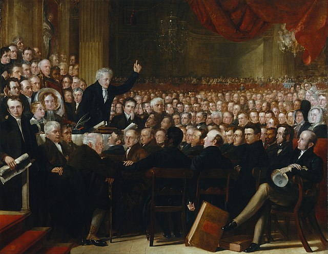
⛓️ The Anti-Slavery Society Convention, 1840 by Benjamin Robert Haydon — Oil on Canvas, 297 × 383 cm
📄 Public Domain | Now held at the National Portrait Gallery, London | 3600 × 2798 px | Wikimedia Commons
📋 Image Source Table — Anti-Slavery Movement
| Image Description & Caption | Source Link & License |
|---|---|
| Anti-Slavery Society Convention, 1840 — by Benjamin Robert Haydon. | Wikimedia (JPG, 3600×2798) | Public Domain |
📚 Primary Scientific References
- Sparrman, Anders. A Voyage to the Cape of Good Hope, towards the Antarctic Polar Circle, and Round the World; but chiefly into the Country of the Hottentots and Caffres, from the Year 1772, to 1776. London: G.G.J. and J. Robinson, 1785. — Primary source for Cook’s Second Voyage from a naturalist’s perspective.
- Beaglehole, J.C. The Life of Captain James Cook. London: A. & C. Black, 1974. ISBN 978-0-7136-1382-1. — Definitive biography; detailed account of the 1772–1775 circumnavigation.
- Martin, James Kirby. Benedict Arnold, Revolutionary Hero: An American Warrior Reconsidered. New York: NYU Press, 1997. ISBN 978-0-8147-5560-2. — Scholarly reassessment of Arnold’s Quebec march.
- Hatch, Robert McConnell. Thrust for Canada: The American Attempt on Quebec in 1775–1776. Boston: Houghton Mifflin, 1979. — Primary monograph on the invasion of Quebec.
- Fischer, David Hackett. Washington’s Crossing. New York: Oxford University Press, 2004. ISBN 978-0-19-517034-4. Pulitzer Prize for History. — Definitive account of the “Ten Crucial Days.”
- Stryker, William S. The Battles of Trenton and Princeton. Boston: Houghton Mifflin, 1898. — Classic military history of the NJ campaign.
- Footner, Hulbert. Sailor of Fortune: The Life and Adventures of Commodore Barney, USN. New York: Harper & Brothers, 1940. — Standard biography of Joshua Barney.
- Library of Congress, Geography and Map Division. “American Revolution and Its Era: Maps and Charts of North America, 1750–1789.” loc.gov — Collection containing all LOC maps cited in this article.
- National Archives and Records Administration. “Records of the Continental and Confederation Congresses.” NARA Record Group 360. — Source of NARA photographs 301685 and 20809306.
- Haydon, Benjamin Robert. The Anti-Slavery Society Convention, 1840. Oil on canvas, 297 × 383 cm. National Portrait Gallery, London (NPG 599). — Primary artwork for the 1840 convention.
- Midgley, Clare. Women Against Slavery: The British Campaigns, 1780–1870. London: Routledge, 1992. ISBN 978-0-415-07018-5. — Scholarly analysis of the 1840 convention’s impact on women’s rights.
- Stewart, David O. The Summer of 1787: The Men Who Invented the Constitution. New York: Simon & Schuster, 2007. — Context for the Revolutionary period.