
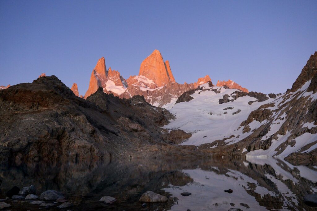

📷 Photo: Todor Bozhinov / Wikimedia Commons | License: CC BY-SA 3.0 | Source: Wikimedia Commons
📍 GPS: 49°16'S, 73°02'W
Laguna de los Tres (Fitz Roy) — Complete Hiking & Photo Guide 2026
Table of Contents
Patagonia's most iconic day hike — a 25 km round-trip trek from El Chaltén to a turquoise glacial lagoon at the base of Mount Fitz Roy (3,405 m). This complete guide covers every angle of the trail with 20 verified photographs from Wikimedia Commons, a kilometer-by-kilometer breakdown, gear recommendations, and honest pros and cons from the expert travel team at www.atechsur.org.
Overview & Quick Facts
Patagonia's most iconic day hike — 25 km to glacial lagoon at base of Mount Fitz Roy (3,405 m).
Rating: ★ 4.9 (12,800+ reviews)
Address: El Chaltén, Santa Cruz, Argentina
Hours: Trail open 24 hrs (register at park office)
GPS: -49.2714, -73.0432
Distance: 25 km round trip
Elevation Gain: 740 m (final 400 m steep moraine)
Difficulty: Moderate to Strenuous
Duration: 8–10 hours
Cost: Free (Los Glaciares National Park, no entrance fee for hiking)
Photo Gallery — 20 Stunning Angles
Every angle of Mount Fitz Roy reveals a different character. Below is a curated collection of 20 photographs from Wikimedia Commons, showcasing the massif from various viewpoints, seasons, and lighting conditions. All images are sourced from verified Creative Commons-licensed photographs.
1. The Classic View: Laguna de los Tres
📷 Todor Bozhinov / Wikimedia Commons | CC BY-SA 3.0 | Source
2. Fitz Roy Above Laguna Sucia

📷 Wikimedia Commons | CC BY-SA 4.0 | Source
3. Golden Hour at Laguna Capri

📷 Panoramio / Wikimedia Commons | CC BY 3.0 | Source
4. Dramatic Black & White

📷 Wikimedia Commons | CC BY-SA 3.0 | Source
5. Cerro Torre — The Impossible Needle

📷 Wikimedia Commons | CC BY-SA 4.0 | Source
6. Lenticular Clouds — The Smoking Mountain

📷 Wikimedia Commons | CC BY-SA 4.0 | Source
7. El Chaltén — Argentina's Trekking Capital

📷 Wikimedia Commons | CC BY-SA 3.0 | Source
8. Town with Fitz Roy Backdrop

📷 Wikimedia Commons | CC BY-SA 4.0 | Source
9. Village Life Below the Peaks

📷 Wikimedia Commons | CC BY-SA 4.0 | Source
10. Laguna Sucia Close-Up

📷 Wikimedia Commons | CC BY-SA 4.0 | Source
11. Los Glaciares Wide Panorama

📷 Wikimedia Commons | CC BY-SA 3.0 | Source
12. On the Trail — Forest Section

📷 Wikimedia Commons | CC BY-SA 3.0 | Source
13. The Complete Massif

📷 Wikimedia Commons | CC BY-SA 4.0 | Source
14. The Approach — First Glimpse from the Road

📷 Wikimedia Commons | CC BY-SA 3.0 | Source
15. Patagonian Fox at the Lagoon

📷 Wikimedia Commons | CC BY-SA 4.0 | Source
16. Blue Ice — Glaciar Piedras Blancas

📷 Wikimedia Commons | CC BY-SA 4.0 | Source
17. Rio de las Vueltas Valley Approach

📷 Panoramio / Wikimedia Commons | CC BY 3.0 | Source
18. The Big Picture — Loma del Pliegue Tumbado

📷 Wikimedia Commons | CC BY-SA 4.0 | Source
19. Second Panoramic Viewpoint

📷 Wikimedia Commons | CC BY-SA 3.0 | Source
20. Historic View — 1994

📷 Wikimedia Commons | CC BY-SA 3.0 | Source
Trail Breakdown — Kilometer by Kilometer
The Laguna de los Tres trail is a 25 km (round trip) out-and-back hike starting from El Chaltén. Here is what to expect at each stage:
Fitz Roy Sunrise Guide
The famous “alpenglow” turns Fitz Roy's granite spires deep orange-red at sunrise. There are two ways to catch it:
Option 1: Night Hike (Same Day)
Leave El Chaltén at 2:00–3:00 AM with a headlamp. Reach the lagoon by 5:30–6:00 AM. Pros: no camping gear needed. Cons: hiking in the dark is challenging, especially the moraine section.
Option 2: Camp at Poincenot (Recommended)
Hike to Campamento Poincenot in the afternoon. Set up camp. Wake at 4:30 AM and hike 1 hour to the lagoon for sunrise. Pros: much easier, can rest beforehand. Cons: need to carry camping gear (the campsite is free, first-come-first-served).
History & Naming
The Tehuelche indigenous people called the mountain Chaltén, meaning “smoking mountain” or “peak of fire,” because lenticular clouds often cloak the summit like volcanic smoke. The name was later adopted for the town at its base.
The Western name “Fitz Roy” comes from Robert FitzRoy, captain of HMS Beagle during Charles Darwin's famous voyage. Argentine explorer Francisco Moreno named the peak in his honor in 1877, though FitzRoy himself never came close to the mountain.
The first ascent was achieved on February 2, 1952, by French alpinists Lionel Terray and Guido Magnone. The climb was considered one of the greatest mountaineering achievements of the era. Today, Fitz Roy remains one of the most technically challenging peaks in the world, attempted by only a few dozen climbers per year.
Did You Know?
The famous outdoor brand Patagonia's logo is a silhouette of the Fitz Roy massif. Founder Yvon Chouinard climbed the mountain in 1968 and was so inspired he named his company after the region.
El Chaltén was founded on October 12, 1985, making it one of the youngest towns in Argentina. It was established partly to assert Argentine sovereignty in a border dispute with Chile over the Fitz Roy area.
Wind speeds at the summit of Fitz Roy regularly exceed 100 km/h. Climbing windows are so rare that expeditions sometimes wait 2–3 weeks for a single calm day.
The summit of Fitz Roy is visible from El Chaltén only about 60–65 days per year. Most visitors never see the peak without clouds. Seeing a clear Fitz Roy is considered very lucky.
Charles Darwin sailed past the Fitz Roy massif aboard HMS Beagle in 1834 but never came ashore in this area. He described the region's glaciers from the ship.
Unlike Torres del Paine (Chile) which charges ~$35 USD entry, the Argentine side of Los Glaciares around El Chaltén charges no entrance fee for hikers. All trails are free.
Stream water along the trail comes directly from glacial melt and is safe to drink without filtering. Locals and experienced hikers drink directly from the streams.
Despite its wild appearance, El Chaltén is just 3 hours by bus from El Calafate airport, which has daily flights from Buenos Aires. You can be at the trailhead within half a day of landing.
Do's & Don'ts
✓ DO
- Start early (6:00–7:00 AM) to avoid afternoon wind and crowded moraine
- Bring at least 2 liters of water plus a refillable bottle (streams at km 4 and 8)
- Pack layers — temperature can swing 20°C in a single day
- Bring trekking poles for the moraine scramble (saves your knees on descent)
- Check the weather forecast at the park ranger station before departing
- Register at the trailhead — it is mandatory and helps search & rescue
- Take the Laguna Sucia detour at the top (15 min, spectacular views)
- Carry a windproof jacket even on sunny days — conditions change in minutes
- Stop at Laguna Capri on the way back for Fitz Roy reflections
- Leave no trace — carry all garbage out, including fruit peels and cores
✗ DON'T
- Don't start after 10:00 AM in summer — you risk descending in the dark
- Don't attempt in heavy rain or storm warnings (moraine becomes dangerously slippery)
- Don't rely on cell signal — there is zero reception on the trail
- Don't feed the foxes or any wildlife (hefty fines apply)
- Don't make fires anywhere outside designated campsite areas
- Don't camp at Laguna de los Tres (camping is forbidden at the lagoon itself)
- Don't underestimate the final kilometer — 400 m elevation on loose rocks is exhausting
- Don't skip sunscreen and sunglasses (UV at altitude + reflection off glacial water)
- Don't wear cotton — wet cotton in Patagonian wind causes rapid heat loss
- Don't leave valuables in your tent at Poincenot (foxes can open zippers)
Pros & Cons
✅ Pros
- Free — no park entrance fee, no permits, no guide required
- One of the most spectacular day hikes on Earth with world-class scenery
- Well-marked trail — impossible to get lost on the main path
- El Chaltén is compact — walk to trailhead from any hostel in 10 min
- Drinkable stream water eliminates need for heavy water carrying
- Free campsites along the route (Poincenot, De Agostini)
- Multiple viewpoints (Laguna Capri, Laguna Sucia) add variety
- Wildlife encounters (foxes, condors, woodpeckers) are common
❌ Cons
- Weather is extremely unpredictable — clear summit views are not guaranteed
- Final moraine is physically demanding (400 m steep on loose rock)
- Very crowded in peak season (January–February), especially at the lagoon
- Wind can be brutal and exhausting, especially on exposed sections
- 25 km round trip is too long for unfit or inexperienced hikers
- No emergency services or shelters on the trail
- Getting to El Chaltén requires 3-hour bus from El Calafate (no airport)
- Accommodation in El Chaltén is expensive and books out months ahead in peak season
Essential Gear List
Clothing Layers
Equipment
Best Time to Visit
☀️ Summer (December–February)
Best for: Longest daylight (16+ hours), warmest temps (5–20°C), all trails open.
Downside: Most crowded. Book accommodation 3–6 months ahead. Wind peaks in January.
🌸 Spring (October–November)
Best for: Fewer crowds, wildflowers blooming, competitive prices.
Downside: Some trails may have snow patches. Shorter days. Weather is more variable.
🍂 Autumn (March–April)
Best for: Golden lenga forest, stable weather windows, fewer hikers. Many consider this the sweet spot.
Downside: Days shorten rapidly. Some services close in late April. Colder nights.
❄️ Winter (May–September)
Best for: Solitude, snow-covered landscapes, lowest prices.
Downside: Short days (8 hours). Many hotels and restaurants closed. Trail may require crampons. Not recommended without winter hiking experience.
Frequently Asked Questions
How difficult is the Laguna de los Tres hike?
The trail is rated moderate to strenuous. The first 8 km are easy through forest. The final 1 km is the hard part — a steep 400 m climb on loose rock. Anyone with reasonable fitness who hikes regularly can complete it, but it is not suitable for complete beginners or those with knee problems.
Do I need a guide for Laguna de los Tres?
No. The trail is very well-marked with signs, painted markers, and a clear path. Thousands of hikers complete it independently every season. A guide is only useful if you want deeper knowledge about geology, flora, and fauna.
Is there an entrance fee for Los Glaciares National Park (El Chaltén sector)?
No. Unlike the Perito Moreno Glacier sector, hiking in the El Chaltén sector of Los Glaciares National Park is completely free. You only need to register at the park ranger office at the entrance to town.
Can I camp at Laguna de los Tres?
No, camping is prohibited at the lagoon. The nearest free campsite is Campamento Poincenot, about 1 hour below the lagoon. It has basic toilet facilities and is first-come-first-served. Alternatively, Campamento De Agostini is nearby.
How do I get to El Chaltén?
Fly into El Calafate Airport (FTE) from Buenos Aires (2.5–3 hour flight). From El Calafate, take a bus to El Chaltén (3 hours, multiple daily departures by Chalten Travel or TAQSA). There is no airport in El Chaltén.
Is the stream water really safe to drink?
Yes, the glacial meltwater streams along the trail are considered safe to drink. The water comes directly from ice and rock with no upstream contamination. Locals and park rangers confirm this. However, if you have a sensitive stomach, a lightweight filter provides extra peace of mind.
What if the weather is bad on my only available day?
If Fitz Roy is completely hidden by clouds, the hike is still beautiful through forest and to Laguna Capri, but the reward at the top is significantly diminished. Consider doing the Cerro Torre trail as an alternative — the lagoon and glacier are impressive even in bad weather. If possible, plan 2–3 days in El Chaltén to maximize your chances of a clear day.